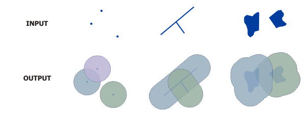
The Buffer Creator Processor can be used to dynamically create a buffer around a GeoEvent's geometry.

This processor requires the field containing the GeoEvent's geometry to be specified. The field name or a tag applied to a field within a GeoEvent Definition can be used to identify the geometry field.
This processor can be configured to either replace the GeoEvent's geometry with the computed buffer or place the computed buffer into a new field. Altering a GeoEvent's schema by adding a new field requires GeoEvent Server to create a new GeoEvent Definition. The new GeoEvent Definition will be managed by GeoEvent Server and deleted if changes are made to the processor or the GeoEvent Service in which the processor participates.
When creating a geometric buffer, you must specify the linear units and a numeric distance for the buffer. GeoEvent Server does not support buffers measured in angular units (for example, decimal degrees). The Buffer Creator interface provides a list with common linear units such as feet, yard, meter, kilometer, and nautical mile. GeoEvent Server administrators can configure the units for the processor through the GeoEvent Manager. The buffer distance is specified as a positive integer value.
When computing a buffer, it is sometimes necessary to specify a projection other than the one associated with the geometry being buffered. For example, point locations received in the WGS84 coordinate system cannot be buffered in that same coordinate system. A projected coordinate system, roughly centered within the expected extent of the expected event geometries, should be chosen instead. When specifying a projection other than the one associated with the GeoEvent geometries being received, use the numeric Well Known Identifier (WKID) of the most appropriate projection.
For more information on the Buffer Creator Processor, see the Introduction to GeoEvent Server tutorial available from GeoEvent Server tutorials.